21 Mar 2008, 12:10 · Topic 661 · Post 2511
Τι θα λέγατε για ελεύθερους χάρτες 1/50000?
Δείτε το πιο κάτω δημοσίευμα:
Μπορείτε να κατεβάσετε τους χάρτες αυτούς από εδώ:
http://maps.poehali.org/en
Για όσους θέλουν να τους κατεβάσουν και να τους καλιμπράρουν στον Ozi μπορούν να το κάνουν με βάση τα εξής στοιχεία:
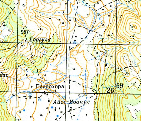
Για να πάρετε μια γεύση αναδημοσιεύω ένα χάρτη εδώ:

Το άρθρο βασίζεται σε αναζήτηση που έκανε ο Peter Σταυρόπουλος.
Δείτε το πιο κάτω δημοσίευμα:
Russian Military Mapping
As a world superpower, the Soviet military initiated an unprecedented worldwide mapping effort to cover the entire globe. World-class topographic mapping has been a natural concern for Russia throughout its history, supporting the defense of its homeland as well as the expansion of its empire. The mapping became available after the break up of the Soviet Union. Large scales maps would be the best choice for the parts of the world where no better locally produced mapping is available.
Dating from the seventies through the nineties and produced at scales from 1:1,000,000 to 1:100,000 and 1:50,000 scales still represent the best accessible coverage for many countries.
A unique feature characterizing Russian mapping is its uniformity in terms of indexing system, geodetic parameters and symbolization rules. All maps are published in Gauss-Kruger conformal projection using Pulkovo 1942 datum on Krassovsky 1940 ellipsoid. The standards for symbolization were established more than fifty years ago and incorporate more features than any other mapping in the world. Some map series especially at 1:100,000 and 1:50,000 scale include information about terrain and transportation network conditions.
The maps can be provided in paper or raster form; however, in certain cases only raster-based products are available.
Μπορείτε να κατεβάσετε τους χάρτες αυτούς από εδώ:
http://maps.poehali.org/en
Για όσους θέλουν να τους κατεβάσουν και να τους καλιμπράρουν στον Ozi μπορούν να το κάνουν με βάση τα εξής στοιχεία:
Specification for 1:50,000 Russian map
Projection: Gauss Kruger
Datum: Pulkovo 1942
Ellipsoid: Krassovsky 1940
Contours: 10 meters in plains, deserts, hilly and low-mountainous areas;
20 meters in high-mountainous areas
Extent: The equator to the 60th parallel: 15x10 minutes
Between the 60th and 76th parallels: 30x10 minutes
Between the 76th and 84th parallels: 60x10 minutes
Language: Russian
Για να πάρετε μια γεύση αναδημοσιεύω ένα χάρτη εδώ:
Το άρθρο βασίζεται σε αναζήτηση που έκανε ο Peter Σταυρόπουλος.